There is a wealth of information about the Coast to Coast online. You can find all you want with a few searches. This page focuses on a few particular observations and ideas that seem poorly covered elsewhere.
The Basics
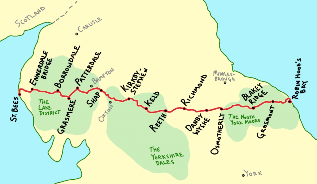
The Coast to Coast Walk is a continuous walking route across northern England. The Walk starts at the small coastal town of St. Bees on the Irish Sea, and proceeds eastward over the Lake District (mountains and lake), the Yorkshire Dales (verdant valleys), Vale of Mowbray (farms), and the North York Moors (moist plateau). It’s over 190 miles in all, through a diverse assortments of landscapes and footpaths.
The route passes through towns of all sizes every 8-12 miles or so, from a simple crossroads to the largest – Richmond – a relaxed village of 8,000. Along the way, there’s a well-established network of inns, hostels, farms and more, catering to all classes of foot travelers. The entire length can be walked in about 2 weeks.
Here is a simplified overview of the route. The towns in black are where we stopped each evening, and make up a fairly standard itinerary. The towns in grey are either alternate stops, or larger cities of note.
Planning a Trip
Most walkers plan and book their trip well in advance. Due to the nature of the accommodations, it can be difficult to book as you go, or change your itinerary on the fly. Most people book everything during the winter prior to their trip. Much later, and things start to fill up, giving you fewer options. It is possible to do things more last-minute, but a lot more work.
The majority of Coast to Coast walkers book their trip through a booking company or agent. There are a few of these, who offer varying services & degrees of flexibility.
One of those services is baggage transfer – just tag your heavy things, and leave them at the hotel. After you’ve set off for the day, someone will shuttle your luggage to your next stop. All you need to carry is a light day-pack with snacks and water. It’s pretty easy to get used to.
Trail Tread & Footwear
There are some sections of the trail with a lot of rocks, in which case a thicker shoe sole would be nice. There are a few moist bits where a waterproof shoe would be nice. But these types of areas are brief – for the most part, the terrain is gentle and well-maintained. I’d recommend lighter comfortable low-top shoes that breathe well. Some kind of waterproof membrane can be nice though, as you’ll find yourself walking along places where you sink into the muck about 2-3 inches every step.
Bogs
You might read about how boggy and wet the Coast to Coast is (including the bit I just wrote above). There are some parts like this, but it’s mostly very brief – like a couple minutes and you’re past it. The boggiest bit is from Kirkby-Stephen to Keld – from the top of Nine Standards Rigg, and then for the next 7 miles or so. In this section, just deal with wet feet for a day – it passes quickly.
Doing the Walk on a budget, or without much planning.
Staying in small inns and B&Bs every night can get pricey. Then, you have to add meals and baggage transfer service. If you want to stick to a budget, consider pitching a tent, and/or staying in camping barns, and on farms. There are quite a few options – it just might take more searching. This same strategy applies if you haven’t planned in advance much. If you’re pitching a tent each night, you should be able to find space as you go.
If you’re doing this, you definitely need to research though, as many of the camping options are not right on the route (though very close), you’ll need to know where you’re going. You’ll have to carry a bit more with you, but you should be able to suffice with a reasonably light kit. For example, you shouldn’t need a stove or cookware, nor carry too much food – if you’re willing to eat out.
Mid-day stops
I highly recommend refreshing yourself at the various cafes, honesty boxes, tea & scone shops, and whatnot along the way. Some people just blow by these things, but to me they’re part of what makes the Coast to Coast such a joy. If you hear of a little village slightly off-route (e.g. Muker), check it out.
When to go
There is a lot written about this elsewhere, but we were really happy to go in June. Any decision is a gamble on the weather. Ours paid-off – the days were long, not too hot, and everything was lush and green.
Water on trail
There is surface water along the trail, but you shouldn’t need to drink it, nor bring any kind of filter or pump. Just start with the water you’ll need that day, considering if you’ll be able to refill somewhere along the way. We carried about 1.5 liters capacity per person, but rarely needed it (it was fairly cool during our hike).
Navigating
The route of the Coast to Coast Walk is more challenging to navigate than you might expect. While it’s mostly on well-established roads and trails, there are a lot of intersections with other roads and trails, and it’s not always evident which way to go. The signage can be good in some areas, then one key junction will be unmarked and not obvious. It’s easy to take a wrong fork in the road. (On one particular occasion – right near the side-hike to Muker – I saw some other walkers doing this, then other groups behind them followed along… they were too far for me to say anything. So, they walked an extra mile or two uphill on a slightly less scenic route.)
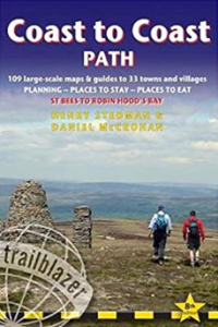
There are a number of guidebook and map options. The most popular book was this one:
We also had this book, and it is pretty good & accurate. It was especially useful each evening to read the description of the next day’s section. The guide books are generally updated by their publishers each year, though most of those changes are to things like lodging & restaurant options. The route doesn’t change significantly year-to-year.
The book was ok, but we found a good GPS extremely useful, and used this for 99% of our real-time navigation. There are a few options here as well. I was pretty happy with how we approached this, as it seemed better (and cheaper) than other GPS options I saw. I downloaded the UK Map app on my phone:
This includes access to UK Ordinance Survey maps of the entire country. These are extremely detailed topographic maps including all the public right-of-way routes throughout the countryside – these are very useful if you need to travel off-route a bit (which is common to get to your lodgings). You can use the app to download the maps you need in advance, for ‘offline’ use (so you don’t need any cell data connection).
After installing the app, you will need to download a GPS overlay of the route. Exactly how to do this in the UK Map app is not exactly intuitive, but it is simple. Here’s how: After installing the app, go to the browser on your phone, and navigate directly to the url of a .gpx file online. You may have to manually type it in the address bar of your browser. I’ve uploaded a copy of the one I used here:
http://www.phlumf.com/temp/coast-to-coast-route.gpx
(This also includes marked waypoints of the places we stayed, and a few other points of interest. I assembled this from various sources in google maps, then exported the gpx file.)
When you do this, your browser should give you the option to install it in the UK Map app. That’s it.
Alternate Routes
There are a lot of alternate routes along the way. It’s always a personal choice. Just consider – Higher routes have more sweeping vistas, lower routes have more human interest.
If I had an extra day
If I had one more day, it might have been nice to go from Patterdale to Bampton, then Bampton to Orton, and onward… This skips Shap, and shortens an otherwise long Patterdale-to-Shap day.
If I had two extra days
With another extra day, I might take a rest day in Richmond. Other choices would be Grasmere or Kirkby Stephen. These are the larger towns with more going on. You might be able to book a tour or taxi to see some of the off-route sights nearby.
If I had more extra days
Some people struggled with the section leading up to Blakey Ridge. Getting picked-up at Cut Bank would be sensible. That will make the following day much shorter, but so it goes. There are other ways you might break-up the rest of the trip, but due to the way the rest of the towns are spaced, it’s easiest to do your last night around Grosmont.

